330 km across the Alps. Italy

Planned route through the Alps, over 330 kilometers long, covered the territories of two countries - Italy and Switzerland... For the first five days, I walked high mountain trails in the Italian part of the Alps, and after crossing the Theodul Pass, I reached the Swiss village of Zermatt... I spent the night three times in high-altitude Alpine bivouacs and once under a tent in stormy conditions at an altitude of over 2000 meters... I started the trek from the town of Domodossola, which was very convenient to reach by direct bus from Milan Malpensa Airport... Due to the convenient logistics, Domodossola became my starting point... I wanted to fly out from my city in the morning and already be on the Alpine trail by the afternoon...
After buying a gas canister in a local hardware store and leaving the town, I found myself fully on the trail of the Alpine mountains...

I had with me food for ten days, weighing a total of 3 kg (500 grams of dry weight per day), and the lightest set of gear I had. Here's a list of the main items - backpack Osprey Talon 44, tent pyramid "Legkoves" (500 grams, including pegs, guys, and adapter for trekking poles), trekking poles (450 grams), down sleeping bag (475 grams and 10 degrees comfort), bivy bag (Tyvek, 200 grams), foil mat (95 grams), thermal underwear (250 grams), storm jacket (150 grams), down jacket (250 grams), two buffs, half-liter steel mug, stove, first aid kit, headlamp, container with a screw cap for making porridge, spoon, two phones, and a power bank...

I was able to fully start the hike at 15:00... Around 21:00, I reached my first overnight stop - Bivacco Emilio Marigonda, covering 20 kilometers and 2000 meters of total elevation gain. A little about places like Alpine bivouacs in Italy... Bivacco are overnight shelters located at high altitudes, established by the Italian Alpine Club. Inside, there are usually about 12 "bunk spots", a stove, and a gas burner, often with a large gas canister. All bivouacs are equipped with solar panels that provide lighting inside, as well as the possibility to charge a phone, but you need to have a 12v adapter, like for charging a phone from a car cigarette lighter. Bivouacs are always open and intended for overnight stays by climbers during ascents... Tourists who are not members of the Alpine Club are also not prohibited from stopping overnight in the bivouac for free, but according to the rules, you can only stay for one night... In some cases, the shelter indicates the bank details of the Alpine Club, where you can "donate" 3-5 euros for the night spent...

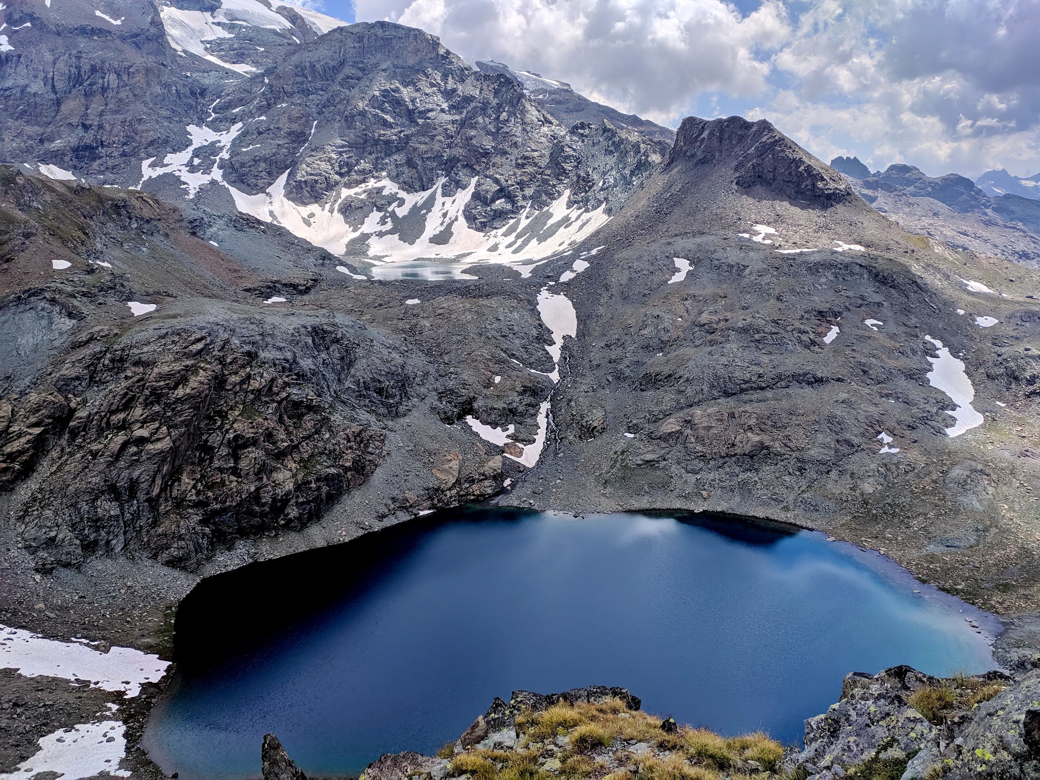
The next day's route passed exclusively along high mountain trails past lakes...


A very cool transition was through the mountain via a tunnel, 2.5 kilometers long... At first, I couldn't believe that the markings pointed to the entrance of a mine...

The route passed along a pipe connecting two lakes, with water flowing from one to the other...


After covering a little over 22 kilometers with a total ascent of 2500 meters, I stopped for the night at Bivacco Cingino (2250 meters)... Finding such a cool place to stay, you don't want to go anywhere else, even if there's still plenty of time...

Inside, there were 15 places to sleep, a table with chairs, and gas canisters left by tourists... Nearby was a spring... I spent this night with a company of Italian teenagers who came to this shelter to have a good evening...

In the morning, I had to climb the Passo di Antigine (2834 meters), after which I found myself on the Swiss side of the Alps for a while...


After walking about 7 kilometers on the Swiss side, I began the ascent to the Monte Moro Pass (2870 meters), beyond which lies the Italian territory... Starting from this ascent, I began to move along the classic TMR (Tour Monte Rosa) route. Interestingly, at the same time, the weather on the Italian side was radically different from sunny Switzerland...


At the pass, there is a monument to the Virgin Mary...

The fog mystically enveloped the entire mountain, and some melody was coming from somewhere... I became very curious about what it was and where the sounds were coming from... And on the descent, near Lake Smeraldo, I met an elderly Swiss couple with small backpacks walking the route, and the man was also carrying a folding Swiss alpine horn on his shoulder... I decided to stop and watch them...

Stopping by the lake - a place with good acoustics, the man unpacked and assembled the national instrument of his country... For about ten minutes, he played the same melodies that had captivated me... All this time, I was a faithful and sole appreciator, not counting his faithful companion...


What distinguishes cool mountain resorts from just good ones is the tourist "goodies"... For example, in this settlement, next to the information office, there was a small tourist building for bookcrossing, where I could rest and charge my smartphone at noon on a very hot day...

After walking 30 kilometers in a day, with a total elevation gain of 2100 meters, I stopped for the night at Bivacco Emiliano Lanti... The shelter has 12 beds with mattresses and blankets, and in a stone utility building, there was also a gas stove connected to a large gas canister... There was also a spring near the shelter...

At first, it was hard to believe that there are such places in the Alps, where you can just enter and stay for free... There was no such "freebie" in Switzerland...


Leaving the classic TMR route, to avoid descending to the settlement of Alagna, I took an alternative and not very well-marked path...


On the descent to the ski resort village of Staffal, part of the municipality of Gressoney-La-Trinité, clouds began to cover the sky, and it started to drizzle... I was lucky to hide under the roof of a bus stop in the village before the heavy rain started... And after waiting no more than half an hour, the sun came out again... The rain stopped, and I continued my ascent...

Having left 31 kilometers of the route and 2600 meters of ascent behind, near a spring at an altitude of 2400 meters, I chose a spot for my tent... Thunderclouds again covered the sky, even stronger and more frightening than before... Literally five minutes later, a squall began and heavy rain turned into hail... The constant roar of thunder and flashes of lightning did not let me relax... I was like in a storm on a ship's deck, holding onto the trekking poles, the main structure of my tent, to prevent it from being blown away... I could only hope that the lightning would pass as far as possible and the guy lines would withstand the strong gusts of wind... Half an hour later, everything ended, and even a rainbow appeared... The storm cloud was already wreaking havoc further down the valley...


At six in the morning, I usually started the route... I liked to meet the dawn higher up in the mountains... I didn't have breakfast immediately after waking up, so in the morning I only needed to dress, pack the tent and sleeping bag, and put my things in the backpack... I had breakfast two to three hours after starting, usually in some cool spot...

As it turned out, I met very few people on the route, even though I was walking in the peak season... Only popular locations saw an influx of tourists. Generally, most go on day hikes to some famous lake or pass, for example from a refuge, then return back... I didn't need to return, as the route always led me forward, besides, my overnight stops were usually much higher than the refuges, and an early start allowed me to be the first on the pass and be there alone... Have breakfast and enjoy the sunrise...


The refuge at the Theodulo Pass... Here I met a Nepali who works at this refuge... He was just talking to his family via video call, showing the glacier on the Swiss side... Exchanging greetings, I descended to the trail, crossing to the Swiss side...


From the Theodulo Pass, there is a ski descent down the glacier... Even in August, the track is groomed, but no one skis... The descent is gentle, so it's absolutely easy to go down on groomed snow in regular sneakers, although my feet got completely wet after the snow... When planning this route, I had doubts about this descent... I wanted to take crampons for my sneakers, but in reality, carrying crampons for the entire route just for this pass made no sense...

On the descent, I saw only one pair of tourists ascending the pass... They were, of course, in crampons and boots, which was much more comfortable... Descending along the lifts and going behind the mountain, I saw another glacier...


The more I descended, the greener the surrounding landscapes became... All around, many waterfalls and green valleys...


On the outskirts of Zermatt lies the picturesque Swiss village of Zum See...

The Swiss forest was also impressive in its uniqueness. The forest on the northern side of the Alps differed from the southern Italian side...

Descending into the village of Zermatt, I headed to a campsite located near the railway station. The town amazes with its charm at every turn, and somehow the large number of tourists at the end of a busy day made me lose the desire to photograph this resort. However, the feeling that you are in a special place did not leave. Since 1931, the use of private cars has been prohibited here. Only hotels, taxis, and service structures are allowed to move by car, which is exclusively electric. You can reach the town by train, leaving your car six kilometers away in the neighboring village of Täsch. Funiculars "fly" over the town itself as one of the types of public transport. There are numerous hotels, shops, cafes, and restaurants. The entrances to the houses on the far hills are organized through tunnels. I have never seen a more sophisticated infrastructure in the mountains. It occurred to me that I did not see people on the trail because few people walk the trails here; there are so many different types of lifts. At the same time, the trails are very well marked...


Reaching Zermatt and covering 37 kilometers and 2000 meters of ascent today, I reached the campsite. After five days of hiking, I covered 140 kilometers of Alpine trails in Italy. The next five days will be under the Swiss flag...
Comments
Post a Comment