330 km across the Alps. Switzerland

The sixth day of the journey started from the camping site in the settlement of Zermatt... For the next five days, my route passed through Switzerland, and on the tenth day, I crossed another pass and in the afternoon found myself on the Italian side... On the eleventh day after lunch, I completed the route in the Italian town of Aosta, having covered a little more than 330 kilometers throughout the entire hike...
Having left the camping site around six in the morning as usual, I continued along the Tour Monte Rose (TMR) route... From the height, views opened up of the fairly large settlement of Zermatt, and the iconic Swiss mountain - the Matterhorn, whose peak was constantly covered by a cloud, although the sky around was relatively clear...


Particularly impressive were the passages through tunnels... Where the path hit a rock, they simply carved out a tunnel... Moreover, the tunnel has lighting... When entering, you turn on the light, and when exiting, you turn off the switch, just like in your room...


Where there are slightly dangerous sections, ropes are stretched... If there is a possibility of rockfall, places are arranged to hide... In a word, there are so many different solutions to make this route accessible to the average tourist along the rocky slope of the ridge that you just realize that such things can only be here...

What is the worth of the Charles Kuonen Suspension Bridge alone, which was the longest in the world at the time of its construction in 2017... The bridge's length reaches 494 meters, and it is stretched at a height of 85 meters from the bottom of the gorge...


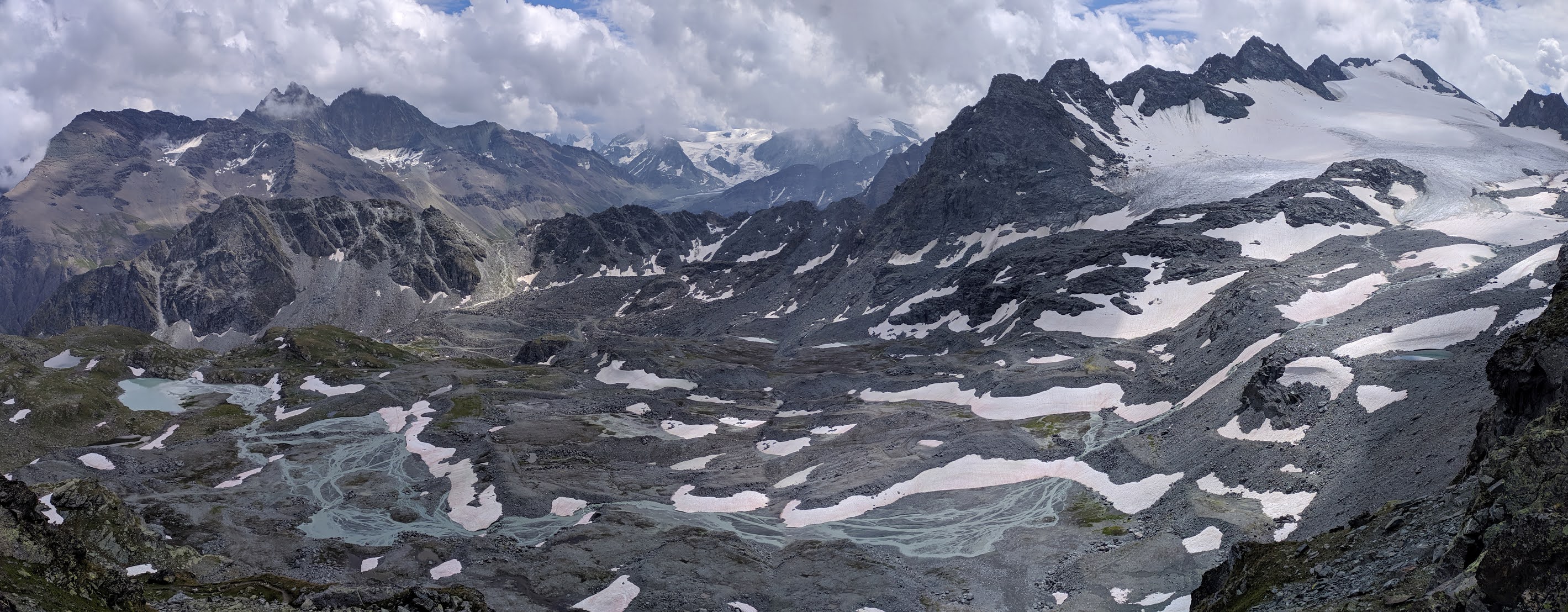
The traverse runs at an average height of 2300 meters, and the peaks of the ridge along which this traverse stretches reach up to 4550 meters...


As often happens in the Alps - changeable weather and afternoon precipitation... After descending from the traverse and descending into the settlement of Saint Nicholas, I waited out the rain and began the ascent to another ridge, transitioning to the route called "Alpenpasse" (Alpine Passes), which I continued to follow for the next four days. Having covered 38 kilometers and 2400 meters of elevation gain in a day, I pitched my tent on the slope of the ridge at an altitude of 1700 meters next to a mountain stream, under the village of Jungu...


The village of Jungu is located at an altitude of almost 2000 meters. Connection with the town of Saint Nicholas is organized by a funicular, that's how simple everything is with the Swiss...


What is interesting about the format of covering a long distance in one hike is the constant change of "scenery", slightly different natural zones cause the appearance of other natural structures...


The classic view of Switzerland - green meadows against the backdrop of snowy peaks...


I stopped for the night after 32 kilometers of the path and a total elevation gain of 2550 meters... Probably the most difficult task is to find an optimal spot for a tent in the mountains, as good and convenient places are usually occupied by pastures, in the forest zone, by rules, you cannot camp either, and in the valley, it's inconvenient because everywhere is private property, and there are not always camping sites... Therefore, it does not always work out to cover more distance and find a good place to stay for the night, and you don't want to break the rules stealthily, just because it is unpleasant to do something that way... So often, I would pitch the tent quite early and had plenty of time to enjoy the views, read a small book I took with me, or listen to music...

The next day, continuing my way along the Alpenpass route, I had to make a loop of almost 6 kilometers because there was a landslide on the main route and it was redirected... Swiss routes pass through quite dangerous areas where rockfalls and landslides can occur... Yet they maintain them so well and keep them safe and up to date that on the one hand, their dangerous route is safer than many of "our" safe ones... Having reached the mountain Corne de Sorebois (2895 m), I began the descent to the lake Lac de Moiry...


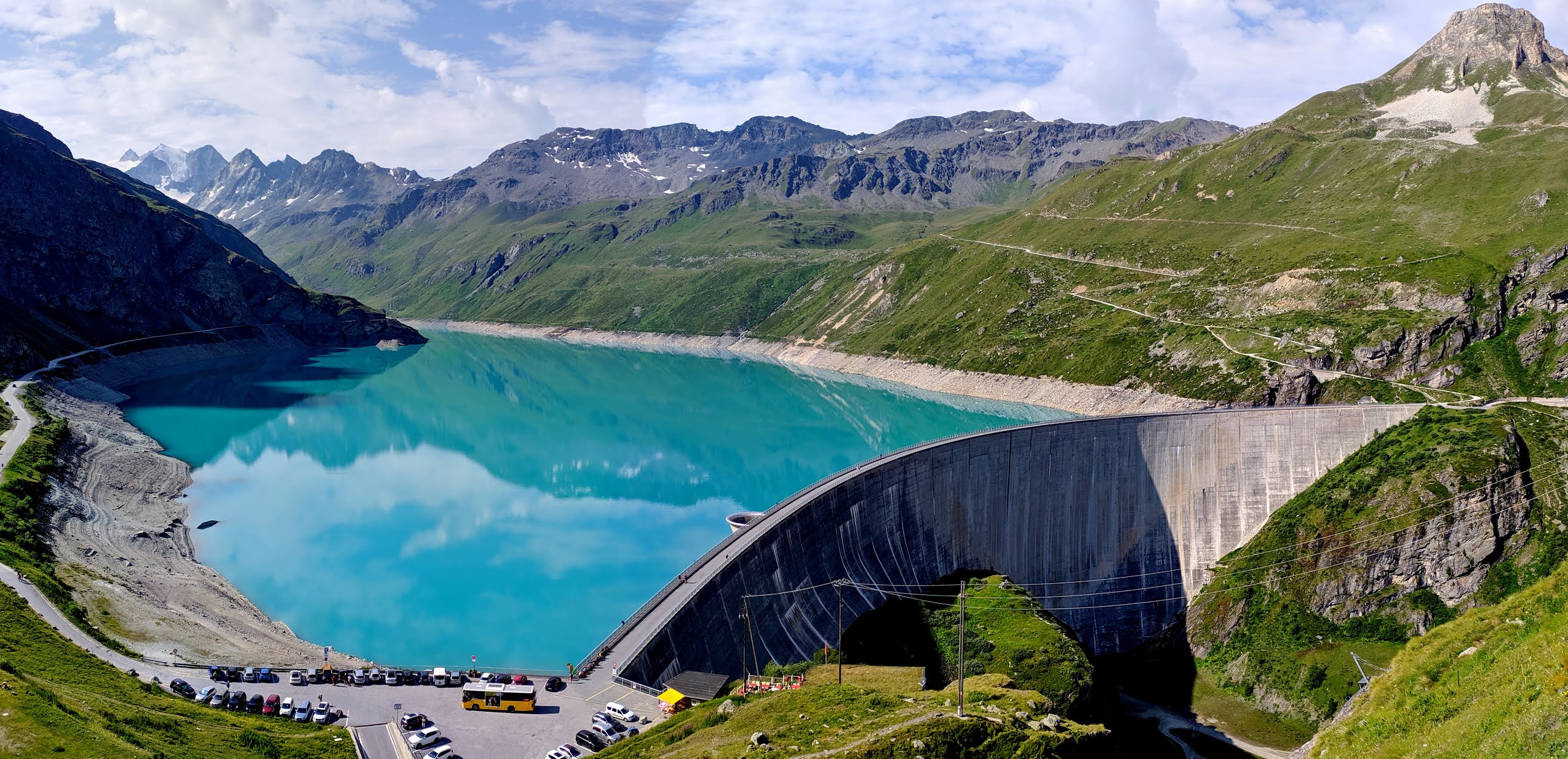
A dam 148 meters high, built back in 1958, created this picturesque lake at an altitude of 2250 meters...


Having covered 41 kilometers and 2660 meters of total elevation gain, I stopped for the night at the campsite in the settlement of Arolla... The average price for accommodation in Swiss campsites, converted from francs to euros, is about 16 euros (about 8 euros for a tent, and 7 - 7.50 per person)... In the campsites, besides the place for a tent, there are toilets, showers, kitchens, and free WiFi... If you arrive at the campsites after 20:00, in most cases the administration will already be closed, and you can stay overnight for free and pay for accommodation when the administration opens, which is no earlier than 8:00 in the morning... But I always finished earlier than eight in the evening, when the administration was still open... The next morning I continued along the "Alpine Passes" route... Swiss mountain hotels impress with their design... Almost all building facades are adorned with live flowers..


And climbing a bit higher, the mountains start to impress... The coolest thing in the mountains is to meet the first rays of the sun...


Not always in the mountains are the paths pleasant and the views "cute"... Rocks, rugged landscapes, muddy streams, all this also occurs along the way...


Col de Prafleuri Pass (2987 m)...


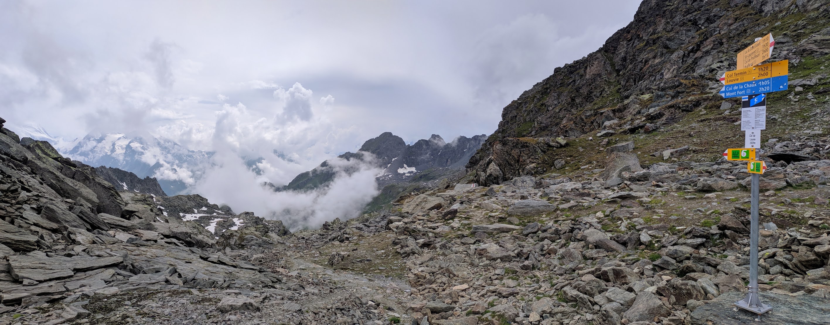
Col de Louvie Pass (2921 m)...
The coolest place for an overnight stay during the trip was the next one... As I descended from the pass, the weather suddenly began to deteriorate, and the sky was completely covered with clouds... It was clear that rain was coming, and this time it would be prolonged... I had already covered 28 kilometers and my total elevation gain for the day had exceeded 2000 m... I planned to go at least another 7 kilometers, but the prospect of getting completely soaked was not appealing... As soon as the first drops of the downpour began to fall from the sky, I went around the corner of the mountain and saw a stone shelter... It was like a super gift...

The place was quite ascetic, but clean, just what I love... Inside, there was a wooden platform for three sleeping places... Here I stopped for the night around four in the afternoon... For the rest of the day and all night, with only short breaks, the rain poured down. The back wall of this hut was a large rock, around which the shelter was built... The rain was so heavy that water began to trickle down from this rock, but inside it was relatively dry and comfortable... It felt like being in a goblin's hut...


Col Sarshlau Pass (2622 m)...

In complete fog, I approached the foot of the 250-meter-high Mauvoisin Dam... The exit to the artificially created Lac de Mauvoisin passed through a tunnel in the rock, where along the passage historical photos of the construction of the Mauvoisin Dam in 1951-1957 were displayed...


Exiting the tunnel, the road went along the entire lake...


The last pass Fenetre de Durand (2806 m) and the Swiss-Italian border, symbolized by a stone pillar...

Lake Lac De La Baseja...

I stopped for the night at Bivacco Regondi-Gavazzi, having covered 33 kilometers with a total elevation gain of 2560 meters...

In previous Italian Bivacco shelters, I was accompanied by other tourists, but in this alpine shelter, I was alone... I stopped for the night quite early, at three in the afternoon, and had plenty of time to descend to the lake for water and rest in this cool place among the rocky Alps... Especially since an unfavorable weather cycle, which had been chasing me for the second day, continued outside...

In the morning, the thermometer showed four degrees below zero, and fresh snow had fallen outside... Such was the beginning of August, and the altitude was only 2600 m...

In the morning, I was met by the same fog and strong wind, which prompted me to move towards the sunny valley...


The Aosta Valley...


Having covered 28 kilometers, on the eleventh day at noon, I reached Aosta. My goal was achieved. The route turned out to be very intense, picturesque, and extremely interesting. When planning, I focused on the practical aspects of completing it and did not read about the places I would pass, so it was a big surprise for me to see one dam after another, which are among the largest in the world, to pass the longest suspension bridge, to pass through tunnels carved in the rocks, and much more. I just wanted to be as high as possible during the entire hike, so I had with me a calculated amount of food for the whole period, and a tent for sleeping under the open sky. The main practice was to try to be alone...
The overall statistics of the route look like this: 11 days, 330 km, total elevation gain over 20,000 meters, 30 peaks and passes above 2700 meters, 5 - above 3000 meters. The highest point of the route is the pass - 3317 meters, in the august month there was no need to carry special equipment. For the entire period, I did not spend a lot of euro for accommodation, I almost always stayed in a tent or free alpine shelters. As always, in any journey, the most important thing is to believe in yourself and take the first step. I would be glad if my report serves as a small inspiration and helps with the preparation of your adventure. See you in the mountains!
Comments
Post a Comment